
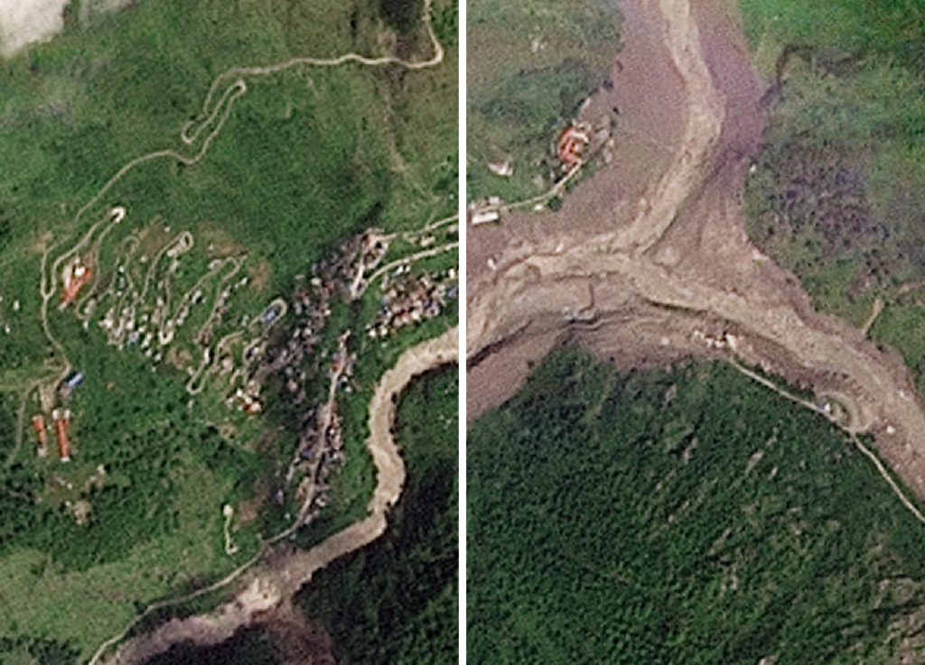
A catastrophic natural disaster unfolded on Wednesday when a glacier high in the Himalayas collapsed, triggering severe flooding along the Nepal-Tibet border. Satellite images have since revealed the widespread destruction caused by this event, showcasing the powerful impact of nature’s forces in one of the most vulnerable mountainous regions on earth.
The glacier collapse occurred in a remote and elevated part of the Himalayas, which is known for its fragile environment and susceptibility to climatic changes. When the glacier gave way, it released an immense volume of water, ice, and debris that rapidly surged down the mountain valleys.
This sudden flood swept through several areas on both sides of the Nepal-Tibet border, devastating villages, infrastructure, and natural landscapes. The affected regions include some of the most densely populated parts of the high-altitude communities, which rely heavily on agriculture, livestock, and traditional livelihoods.
Satellite images provided by various international space agencies and disaster monitoring organizations have been crucial in assessing the extent of the damage. These images clearly show the flooded river valleys, destroyed roads, collapsed bridges, and damaged homes within the affected zones.
Authorities in Nepal and Tibet have activated emergency response teams to aid evacuation, provide medical assistance, and begin the recovery process. The floodwaters have also disrupted transportation and communication links, complicating rescue efforts.
Experts believe that the glacier collapse may be linked with the ongoing effects of climate change. Rising global temperatures accelerate glacial melting and can destabilize ice formations in mountainous regions, increasing the risk of such sudden disasters.
Local communities, government officials, and international humanitarian groups have expressed concerns about the long-term impacts on livelihoods and food security. Damage to agricultural land and interruption of water resources pose significant challenges to recovery and survival in the aftermath of the floods.
Environmental scientists are calling for improved monitoring of Himalayan glaciers and rivers to better predict and prevent future incidents. Enhanced satellite surveillance combined with ground-based sensors could provide early warning systems to protect vulnerable populations.
This tragic event is a stark reminder of the volatile conditions faced by mountain ecosystems and the growing urgency to address climate resilience. With ongoing cooperation between Nepal, Tibet, and international partners, efforts are underway to mitigate the consequences and prepare for potential future risks.
The Nepal-Tibet floods underscore the critical role of advanced technology such as satellite imaging in disaster management. By providing real-time data and comprehensive geographic assessments, these tools enable faster response times and more effective resource allocation.
As the situation stabilizes, focus will turn to rebuilding and strengthening infrastructure to withstand similar events in the future. Sustainable development strategies and climate adaptation plans will be essential to safeguard communities living amid the majestic yet perilous Himalayas.
In summary, the glacier collapse and subsequent flooding caused unprecedented damage along the Nepal-Tibet border. Satellite imagery has made it possible to gauge the scale of the disaster and guide relief operations. The event highlights the intersection of natural hazards and climate change, calling for concerted action to protect fragile mountain environments and the people who depend on them.