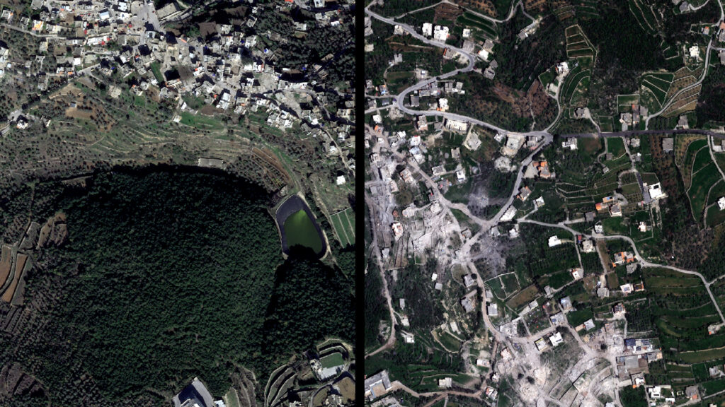
Recent satellite images have brought to light the extensive damage inflicted by the Israeli military on towns in southern Lebanon. These high-resolution images reveal the scale of destruction, showing widespread devastation across multiple inhabited areas.
The images show numerous residential buildings reduced to rubble, infrastructure severely damaged, and entire neighborhoods flattened by military action. Roads, bridges, and public facilities have suffered significant impact, severely disrupting daily life for the local population.
South Lebanon, historically a region marked by conflict, continues to bear the brunt of military operations. The images corroborate reports from local officials and humanitarian organizations, who have documented the aftermath of airstrikes and ground incursions causing civilian displacement and property loss.
This unprecedented visual evidence raises urgent questions about the humanitarian impact of the conflict and the future prospects for reconstruction and return for the displaced residents. The destruction also intensifies concerns regarding regional stability and the potential for further escalation.
International observers and human rights groups have condemned the scale of damage and called for immediate measures to protect civilians and uphold international humanitarian law. The images are expected to prompt renewed diplomatic efforts aimed at de-escalating tensions and facilitating humanitarian aid to affected communities.
As the situation continues to evolve, these satellite images serve as a stark reminder of the human and material costs of conflict in southern Lebanon and underscore the urgent need for peaceful resolution and reconstruction efforts.