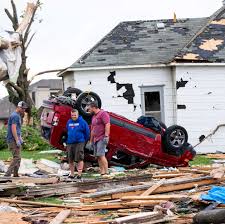
DES MOINES, Iowa — Multiple tornadoes struck Iowa on Tuesday, with one causing multiple deaths and at least a dozen injuries in a small town, after severe weather brought numerous rounds of rain and thunderstorms in the Plains and Midwest.
The tornado touched down in Greenfield, a town about 60 miles southwest of Des Moines, Iowa, on Tuesday afternoon. Iowa State Police confirmed that there were multiple deaths after the tornado almost completely flattened the town of more than 2,000, the Des Moines Register, part of the USA TODAY Network, reported.
Sgt. Alex Dinkla, spokesperson with the Iowa State Patrol, said at a news conference Tuesday night that authorities were working to confirm the exact number of those killed or injured, but estimated at least a dozen people were hospitalized.
Overall, more than 25 million people from Nebraska to Michigan live in the path of a powerful storm system and face a “probable” threat of tornadoes as well as heavy rain, hail and damaging winds, according to the National Weather Service’s Storm Prediction Center.
“We’re concerned about damaging winds and tornadoes. No weather event is the same, but this does have the same kind of earmarks as the severe weather threat back on April 26. There were more than 100 tornadoes reported that day,” AccuWeather meteorologist Bernie Rayno said.
A tornado watch was issued Tuesday afternoon for much of eastern Nebraska and most of Iowa, along with portions of Illinois, Wisconsin, and Minnesota. This means that weather conditions are prime for tornadoes to form there, the Storm Prediction Center said. Much of Iowa was under a “particularly dangerous situation” tornado watch, an alert used only in the most extreme situations.
Severe thunderstorms have prompted reports of road flooding in at least seven counties in Iowa Tuesday afternoon. The weather service received a report of 3.5 inches of rain in Mason City, Iowa, in Cerro Gordo County. Flooding also was reported in Bremer and Grundy counties.
The storm system was expected to reach peak intensity – with the formation of supercells, the most powerful thunderstorm type – in the afternoon and early evening as it reaches the Missouri and Mississippi valleys as well as the Lake Michigan area.


