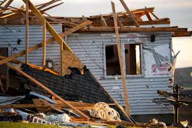
Following tornadoes in Nebraska and tornadoes in Iowa on Friday, The National Weather Service (NWS) is advising residents in both states to prepare for more stormy weather.
The government agency sent out an enhanced risk alert for many parts of Nebraska. In the alert the agency said that residents can expect severe weather again on Saturday. Forecasters have predicted large hail, damaging winds, tornadoes, and flooding between 2 p.m. and midnight.
In Iowa, the NWS says that rain showers and storms are likely to happen in the central and southern parts of the state in the evening hours on Saturday. Storms could be strong to severe and have a large hail (2 inches in diameter) and damaging winds. And the agency also says that a few tornadoes cannot be ruled out. Iowans can expect the severe weather between 3 p.m. and 10 p.m. on Saturday.
The agency also warns that clean-up efforts should be placed on hold for Saturday in both states and residents should take shelter before the storms begins. Even if the area does look safe, there is still an elevated risk of lightning to strike in Nebraska, the agency said.
USA TODAY has reached out to confirm if there were any injuries related to the tornadoes in Nebraska and Iowa but have not heard back.
Video shows tornado in southeast Nebraska
A tornado was spotted on the ground in southeast Nebraska where several warnings have been placed for the western portions of the Omaha metro area.
A massive tornado intercept was seen north of Lincoln, also in Lancaster County, footage posted on X (formerly Twitter) by SevereStudios weather videographer Nick Gorman shows.
At least 10 tornadoes hit central Iowa, National Weather Service says
The National Weather Service in Des Moines posted early Saturday morning that preliminary reports indicate at least 10 tornadoes struck central Iowa in the April 26 storm front, based on initial damage information.
Another band of tornadoes swept across Nebraska and western Iowa.


