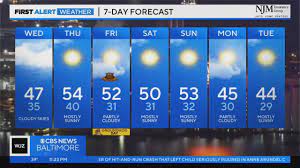
Skies will remain mostly cloudy overnight with lows in the 30s. An upper level disturbance will track southeast toward the area from the Great Lakes overnight through Wednesday morning. This system does not have any moisture to work with, therefore any chances for precip will be restricted to areas south and west of the Baltimore Area and across western Maryland.
Wednesday will see a continuation of cloudy skies with highs in the 40s. The system will exit the area by Wednesday night. The rest of the week will be nice with a mix of sun and clouds on Thursday and Friday with highs in the 50s. A cold front will move through the area Friday morning, bringing cooler weather with it for the weekend.
The weekend will see more sunshine with highs in the 40s. Lows at night will drop into the 20s, very close to where we should be for this time of year.
Most of next week looks dry with clouds and sunshine through next Friday and highs in the 40s and 50s. Lows at night will dip into the 20s and 30s.
The next earliest chance for rain/snow will be next weekend leading up to Valentine’s Day, where a significant weather pattern change is expected. The latter part of February is trending colder, but there is still plenty of time to watch it. Enjoy the mild temperatures while the last.


