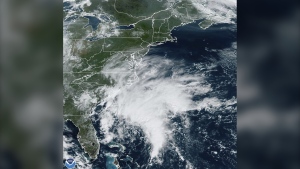
Communities along the U.S. East Coast prepared for heavy rain, flooding and high winds from an approaching storm, dismissing schools early on Friday and canceling weekend events ahead of an expected landfall in North Carolina on Saturday.
Although the system had reached tropical storm strength, it wasn’t yet given a name and the National Hurricane Center was still referring to it as Potential Tropical Cyclone Sixteen on Friday morning. The hurricane center defines a potential tropical cyclone as a disturbance posing a threat of tropical storm or hurricane conditions to land within 48 hours.
People along the Atlantic coast need to be ready because the high wind and rains would worsen during the day Friday and into the weekend, said Meteorologist Maria Torres, a public affairs officer with the Miami-based National Hurricane Center.
“If there’s anything else that you need, this is the time to start making sure that you finish your preparations and stay home,” Torres told The Associated Press.
Rainfall of 3 to 5 inches (7.6 to 12.7 centimeters), with localized amounts up to 7 inches (17.7 centimeters), was expected across eastern North Carolina and into southeast Virginia through Saturday, the center said.
The storm was located about 255 miles (405 kilometers) east of Charleston, South Carolina, and about 200 miles (320 kilometers) south Cape Hatteras, North Carolina, and moving north around 12 mph (19 kph), the center said.
The Cape Hatteras National Seashore was closing campgrounds Friday and the North Carolina Ferry System announced it was suspending several routes. North Carolina’s State Emergency Response Team planned to move to an enhanced watch Friday to ease coordination of resources, the governor’s office said. Schools in coastal areas of North Carolina and Virginia announced plans to dismiss students early Friday and cancel afterschool and weekend activities.
The forecast prompted the cancellation of events across the region, including the Kunta Kinte Heritage Festival, which had been set to return to City Dock in Annapolis, Maryland, on Saturday. Hampton Cup Regatta organizers canceled that event in Virginia saying the forecast wasn’t optimal for hydroplane racing or Friday evening’s concert.
The U.S. Coast Guard closed the ports of Wilmington and Morehead City in North Carolina to all inbound traffic Thursday. The agency expected to close ports in Virginia on Friday afternoon and cease all vessel movements on the Chesapeake Bay south of the Bay Bridge at 10 p.m. Friday, according to Petty Officer Ryan Noel.
The tropical storm warning was in effect from Cape Fear, North Carolina, to Fenwick Island, Delaware. It also includes the Chesapeake Bay south of North Beach, Tidal Potomac south of Cobb Island and Albemarle and Pamlico Sounds. Storm surge warnings were in effect for areas throughout the region, the hurricane center said.
A storm surge warning was in effect from Duck, North Carolina, to Chincoteague, Virginia, including Chesapeake Bay south of Windmill Point, and for the Neuse River, the Pamlico River, and portions of Pamlico Sound.
A storm surge watch also was issued from Surf City in North Carolina to Duck, North Carolina, along with Chesapeake Bay north of Windmill Point to Smith Point, the Tidal Potomac south of Colonial Beach and Albemarle and the remainder of Pamlico Sound.
Meanwhile, Hurricane Nigel was downgraded to a post-tropical cyclone centered about 640 miles (1,030 kilometers) northwest of the Azores with maximum sustained winds of 70 mph (110 kph). There were no associated coastal watches or warnings as the storm moved northeast at 37 mph (59 kph), the hurricane center said in its final update on the system Friday morning.


